
|

|
|
|
|
 |
 |
 |
 |
 |
 |
 |
 |
 |
| September 16, 1999 [Thursday] 2:50-3:00 PM Lafayette Bridge |
| Winds became calm, still a lot of places were under the water. |
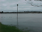 [2:50 PM] Lafayette Bridge. Winds were really picking up and
things were getting rough again. Au contraire, a group
of ducks were staging a pensive atmosphere.
From South side of Lafayette River and New York Ave.
[2:50 PM] Lafayette Bridge. Winds were really picking up and
things were getting rough again. Au contraire, a group
of ducks were staging a pensive atmosphere.
From South side of Lafayette River and New York Ave.
|
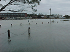 [2:50 PM] Paved sidewalk was now under the water. The building at upper left side
is a good example of FEMA's flood mitigation (i.e., pass-thru first floor).
South side of Lafayette River and New York Ave.
[2:50 PM] Paved sidewalk was now under the water. The building at upper left side
is a good example of FEMA's flood mitigation (i.e., pass-thru first floor).
South side of Lafayette River and New York Ave.
|
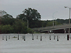 [2:50 PM] All the private piers and docks are under the raging water.
North side of Lafayette Bridge and New York Ave.
[2:50 PM] All the private piers and docks are under the raging water.
North side of Lafayette Bridge and New York Ave.
|
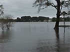 [2:50 PM] Roads under the water.
New hampshire Ave. and Mayflower Rd. junction.
[2:50 PM] Roads under the water.
New hampshire Ave. and Mayflower Rd. junction.
|
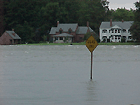 [2:50 PM] Another view with a road sign reference for water level.
New hampshire Ave. and Mayflower Rd. junction.
[2:50 PM] Another view with a road sign reference for water level.
New hampshire Ave. and Mayflower Rd. junction.
|
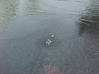 [3:00 PM] Backflush was still going on after Floyd moved out
in a stormwater drain manhole.
Rhode Island Ave. and Colonial Ave.
[3:00 PM] Backflush was still going on after Floyd moved out
in a stormwater drain manhole.
Rhode Island Ave. and Colonial Ave.
|
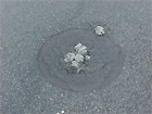 [3:00 PM] Another closer view.
Rhode Island Ave. and Colonial Ave.
[3:00 PM] Another closer view.
Rhode Island Ave. and Colonial Ave.
|
|
|
|
|
|
|
|
|
|
|