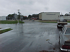
 [4:30 PM] East of O'Sullivan. This section of the road
is prone to inundation even with a low-intensity storm event,
and did miss the beat.
Carolina Ave. and Mayflower Rd. Junction
[4:30 PM] East of O'Sullivan. This section of the road
is prone to inundation even with a low-intensity storm event,
and did miss the beat.
Carolina Ave. and Mayflower Rd. Junction
|
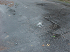 [4:30 PM] East of O'Sullivan. Another stormwater drain manhole backflush.
Carolina Ave. and Mayflower Rd. Junction
[4:30 PM] East of O'Sullivan. Another stormwater drain manhole backflush.
Carolina Ave. and Mayflower Rd. Junction
|
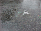 [4:30 PM] Closer look at the stormwater drain manhole backflush.
Carolina Ave. and Mayflower Rd. Junction
[4:30 PM] Closer look at the stormwater drain manhole backflush.
Carolina Ave. and Mayflower Rd. Junction
|
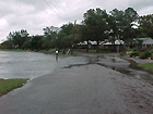
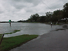 [4:35 PM] Inundated road section.
New York Ave. and Mayflower Rd. Junction
[4:35 PM] Inundated road section.
New York Ave. and Mayflower Rd. Junction
|
 [4:35 PM] Another angle on inundated road section.
New York Ave. and Mayflower Rd. Junction
[4:35 PM] Another angle on inundated road section.
New York Ave. and Mayflower Rd. Junction
|
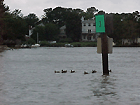 [4:35 PM] Well, it seemed like that mother duck and ducklings made it thru without
a scratch.
New York Ave. and Mayflower Rd. Junction
[4:35 PM] Well, it seemed like that mother duck and ducklings made it thru without
a scratch.
New York Ave. and Mayflower Rd. Junction
|
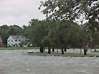 [4:45 PM] High waters.
Northern tip of Mayflower Rd.
[4:45 PM] High waters.
Northern tip of Mayflower Rd.
|
 [4:45 PM] High waters.
Northern tip of Mayflower Rd.
[4:45 PM] High waters.
Northern tip of Mayflower Rd.
|
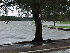 [4:45 PM] High waters.
Northern tip of Mayflower Rd.
[4:45 PM] High waters.
Northern tip of Mayflower Rd.
|
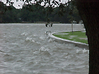 [4:45 PM] High waters.
Northern tip of Mayflower Rd.
[4:45 PM] High waters.
Northern tip of Mayflower Rd.
|
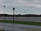 [4:45 PM] High waters.
Western tip of Mayflower Rd.
[4:45 PM] High waters.
Western tip of Mayflower Rd.
|
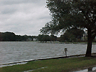
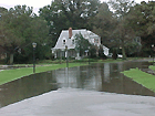 [5:00 PM] Inundated road sections. Well, that was enough for me and I'm going home.
Eastern tip of Mayflower Rd.
[5:00 PM] Inundated road sections. Well, that was enough for me and I'm going home.
Eastern tip of Mayflower Rd.
|