![[access count]](/cgi-bin/Count.cgi?dd=simple|pad=0|frgb=255;215;0&df=cee_model.dat)
|
|
USGS US Water-Resources Cataloging Units (WRCU)
for the US Water Regions Flow data are used in P-ROUTE to represent
stream characteristic. The WRCU is based on U.S. Geological Survey's national
digital data bases compiled from state site-specific data.
|
| |
This means you should know
exact catalog unit number corresponding
to a specific site of your interest to simulate
P-ROUTE using flow databases.
All catalog units are expressed in 8-digit numerical values. Here's
a brief description of how to find, and define catalog unit numbers
for the P-ROUTE simulation.
|
 Structure of Water-Resources Cataloging Units (WRCU)
|
| |
Let's start from an actual WRCU example. A flow
characteristic data of a site in Mid Atlantic
Region, locate in the subregion of the Lower Chesapeake,
in the second accounting unit with geographic description with
Hampton Roads is assigned to a WRCU as
02080208 Hampton Roads
Huh? Well, 02080208
is the WRCU, and
Hampton Roads is the description of
a specific site assigned to the WRCU. The encryptic 8-digit
WRCU is based on a combination of
| 02 |
08 |
02 |
08 |
| 02 |
0208 |
020802 |
02080208 |
| water-resources
region(2-digit water-basin code) |
water-resources
subregion(4-digit water-basin code) |
water-resources accounting unit (6-digit water-basin code) |
water-resources
cataloging unit (8-digit water-basin code) |
|
|
Water-Resources Region
|
| |
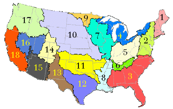
There are 21 water-resources regions in the U.S. as shown below.
List of water-resource regions
-
- 01
- New England Region
- 02
- Mid Atlantic Region
- 03
- South Atlantic-Gulf Region
- 04
- Great Lakes Region
- 05
- Ohio Region
- 06
- Tennessee Region
- 07
- Upper Mississippi Region
- 08
- Lower Mississippi Region
- 09
- Souris-Red-Rainy Region
- 10
- Missouri Region
- 11
- Arkansas-White-Red Region
- 12
- Texas-Gulf Region
- 13
- Rio Grande Region
- 14
- Upper Colorado Region
- 15
- Lower Colorado Region
- 16
- Great Basin Region
- 17
- Pacific Northwest Region
- 18
- California Region
- 19
- Alaska Region
- 20
- Hawaii Region
- 21
- Caribbean Region
Two things you should keep in mind regarding to
above Water-Resources Region list;
- Water-Resources Regions are based on the hydrologic unit, not by
the state boundary. For example, the State of Virginia is
covered by four different Water-Resources Regions, 02, 03, 05, and 06.
Please take a look at the Water-Resources Regions map below.
- P-ROUTE distribution does NOT include Flow data database
files for Water-Resources Regions 19,
20, and 21 (Alaska, Hawaii and Caribbean Regions).
|
|
Water-Resources Subregion
|
| |
Water-resources subregions in each state. Note
that in any state, the data pertains to only
that portion of the subregion that is
within the state boundaries.
List of 4-digits all U.S. water-resource subregions
are available from this website.
-
 |
All U.S. water-resource subregions |
|
|
Water-Resources Cataloging Unit
|
| |
This 8-digit Water-resources cataloging unit is the flow
characteristic data of a site belongs to a water-resources
accounting unit in a subregion that is a part of one of
21 USGS US water-resources region.
It now starts making a sense (based on the hierarchical
cataloging unit assignment) that the WRCU approach could
gurantee uniqueness of a specific site flow characteristic
record, at the same time, it becomes much easier to handle
massive amounts of countinuous field measurement records
thru the WRCU assignment. (actually, I strongly suspect that
the WRCU schema must be designed by a SQL/RDBMS-oriented person for
the sake of making his/her life less stressful from tons of field measurement
data)
|
|
Site-specific WRCU(s) for P-ROUTE simulation
|
| |
For P-ROUTE simulation, you can find site-specific
WRCU(s) by
- Find the region number corresponding to your study site from
the Water-resources region map or from the list
- based on the geographical location of your site, determine
a corresponding the Water-resources subregion number
starting with the region number and its description
- If you found 4-digit number(s) (region+subregion), then
it's relatively easy to find out final WRCU(s) for channel
reaches of your study site by comparing the description of
WRCUs that starts with the same first 4-digit number.
WRCU for Virginia and its adjacent states are available
from this website as below.
-
 |
|
Full 8-digit WRCU databases for the rest of 12 Water-resources regions are
downloadable from the USGS Website |
 |
|
Back to WRR and WRCU section of P-ROUTE page |
|
|
| |
 |
|
Download PDF Reader |
| |
 |
|
Instruction for copying computer modelsbigger than 1.44 MB to multiple floppy disks |

|